Rivers: Safety and Paddling Guides
Knowledge is power!
The Chemung Basin River Trail covers nearly eighty miles in the Chemung Basin. The 45-mile Chemung River is formed by the confluence of the Tioga, Canisteo, and Cohocton Rivers and joins the Susquehanna River at Sayre, PA. The Susquehanna Greenway has tons of river water trail guides.
Information on where to find canoe and kayak rentals, outing clubs, and more can be found on our resource page. You can visit SnoFlo to get conditions on any river in North America, useful in planning paddling trips, fishing outings, and more. You can also find live river levels on our site right here.
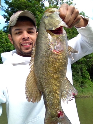
The waters of the Chemung River are dominated by small-mouth bass and walleye. There are also largemouth bass, bullheads, carp, and muskie. Prime fishing is during the summer and fall, but walleye and muskie are active into December. In 2015, NYSDEC released the Chemung River Angler Survey. We have lots of fishing links on our resource page, but you'll want to check out the survey page here.
River Safety Guide
Basic safety is very important, but never forget River Advice to Paddle By!
Have a Coast Guard-approved personal flotation device (PFD); NY requires one wearable, readily accessible PFD for each person aboard a vessel. Bring a whistle that can make a sound audible for a half-mile; it's required to have one for each boat. Bring dry clothes in a watertight bag and wear light clothing, sunglasses, a hat, and sun block, and drink plenty of fluids. Windy, cool, or rainy weather can lead to hypothermia, even in summer. Wear or bring layers of wool pile or polypropylene; avoid cotton.
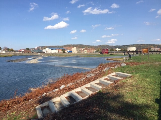
Be aware of river levels. If you are at the river, put a stick in the ground at the edge of the water and wait to see if it is rising or falling. Cancel your trip if the river is rising. Caution! Avoid the dam in Elmira downstream from the Grove Street Launch Site! Use the Don Hall Portage Trail, which allows paddlers to take their boats out of the river above the Chase-Hibbard Dam, carry them up a 63-foot-stairway and along a 730-foot river shore trail, and put them back in the river below the dam. The trail (pictured) is marked on the map below.
Obstacles in the river will form what looks like a "V" pointing upstream, at you. Avoid these and look for Vs pointing downstream to take advantage of the deeper water flowing between these obstacles. Downed trees are called strainers. They can be found outside of river bends and can be dangerous, so look ahead and avoid them. If you're about to collide with an object, lean into it to present the bottom of the canoe to the onrushing water. Leaning away increases the likelihood that you will roll under, swamp the boat, and get entangled.
In rough water, kneel down, keep weight centered and as low as possible. If your boat flips over, hold onto your paddles and the boat, if possible! Keep the boat below you (downstream). Never position yourself downstream of the boat. Lie on your back with your feet downstream until you reach a shallow, calm spot or shoreline, then empty the boat and re-enter. Never try to stand up in fast-moving water.
Let your family and friends know you are on the river, where you put in, and where you plan to pull out. Paddle with others and have an experienced paddler in the group. You can find more about paddling safety, including universal river signals, guidelines for river rescue, and personal preparedness here.
Paddling Guide to the Susquehanna Watershed
Our Chemung River Watershed is but a small portion of the 150 or so boat launches in the Upper Susquehanna Watershed. To view a GeoPDF map of the entire watershed, click here. All boat launches for the Upper Susquehanna are included in the GoogleMap below, too. Click on a site for more information, including river access type, parking spaces, ownership, fees, access to restrooms/drinking water/food/trash cans, signage, and more. Click on the slider box in the upper left of the map to search for specific sites by boat launch number, and to select or deselect rivers (launches are color-coded by river). Don't forget to visit our resource page for many more links you can use and to download our 71-page Kayak and Canoeing Tips!
Monica Li, an avid kayaker, has put together a fantastic resource for you: a comprehensive navigational guide for the river with interactive satellite maps and more! Check out Northeast Rivers. You'll find suggested river trips with lengths, difficulty levels, hazards, and recommendations.
How to Launch and Land a Canoe by Yourself
We're seeing more and more people paddling on the rivers this summer, enjoying the outdoor exercise, beauty, and connection with Mother Nature.
For those who canoe, it can be difficult to launch and land the boat by yourself.
Old Town Canoe and Kayak has shared this video and these great tips (© 2011 Old Town Canoe and Kayak):
Launching
- First, you want to make sure your canoe is down and in the water as much as possible. You're going to slide the canoe out, with the paddle in one hand and the canoe in the other.
- Next, you're going to reach across to the outside gunnel, focusing on keeping your weight low and over the center of the boat.
- Once you have the canoe stable, step into the middle of the canoe, keeping your weight extremely low until you feel stable.
- Then, taking your other foot, place it in the center of the canoe, and get into the kneeling position.
- Now you can push off what's left of the canoe on the shore and be on your way.
Landing
- One of the best ways to do this is to approach the shore sideways, and keeping your weight low, slowly step out of the canoe.
- Don't let go of your canoe, or it might blow away.